Cottonwood Lakes Trail and Map

John Muir Wilderness

photo of Cottonwood Lakes, John Muir Wilderness, California

Cottonwood Lakes Trail and Map

John Muir Wilderness


Following the Trail to Cottonwood Lakes

Hikers setting out from the Horseshoe Meadow trailhead often have different destinations in mind. A good number base camp at Cottonwood Lakes and spend days fishing, exploring, and perhaps climbing Mt. Langley. Others may be heading over New Army Pass on their way to connect to the John Muir Trail and simply to explore southern Sequoia National Park. Others may be crossing Cottonwood Pass and hiking into the Golden Trout Wilderness.

Horseshoe Meadow to New Army Pass Trail Junction, 3.6 miles

The trail passes through lightly forested, rolling terrain for the first 3 miles of the hike, soon joining Cottonwood Creek. Continue past the Golden Trout Camp. The current trail may not match some older maps.

New Army Pass trail sign, John Muir Wilderness, CA

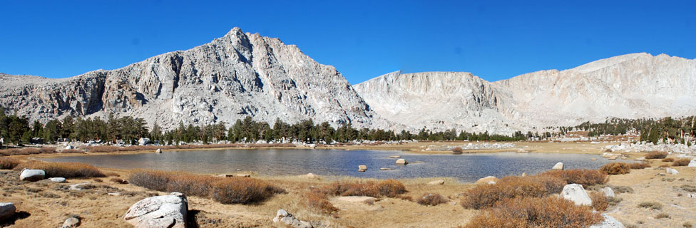
Beyond the Golden Trout Camp, the trail climbs gradually to the junction for New Army Pass. Both trails lead to Cottonwood Lakes. The Cottonwood Lakes trail passes through more open country with views of Mount Langley.

trail to Cottonwood Lakes, John Muir Wilderness, California

Trail to Cottonwood Lakes


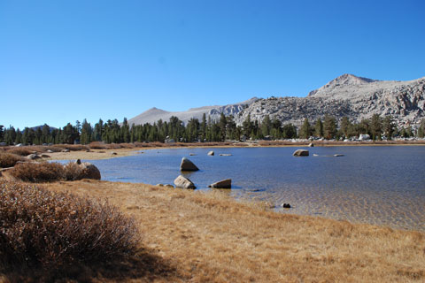
New Army Pass Trail Junction to Cottonwood Lakes, 2.3 miles

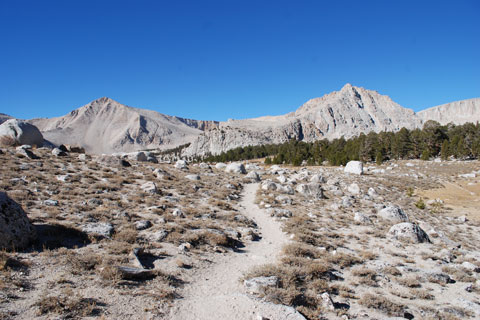
The Cottonwood Lakes trail soon becomes steeper with some switchbacks, but never difficult. After 1.1 miles pass the turnoff to Muir Lake. Some hikers choose scenic Muir Lake for their campsite. After a little more uphill, the trail breaks into the open with views of Mt. Langley and surrounding peaks.

Shop Amazon for: Hiking Poles


A spiderweb of trails lead throughout the Cottonwood Lakes area. Lakes seem to emerge around every corner.


Cottonwood Lakes, John Muir Wilderness, California

Cottonwood Lakes


Along the Way


Cottonwood Sawmill Site

In the 1870s, early pioneer of Inyo County Colonel Sherman Stevens built a sawmill up on Cottonwood Creek to supply mine timbers and smelter fuel to nearby camps in the Owens Valley. Lumber cut at the mill was transported down a 13-mile flume to the shore of Owens Lake and then barged across the lake to mining camps.

In 1877 fire destroyed part of the flume, and at about the same time the mining camps faded. Stevens abandoned the enterprise. Over the years the sawmill's roof caved in. Then years later a fire destroyed most of what remained.

Today few remnants of the sawmill can be seen at its site along Horseshoe Meadows Road, 2 miles northeast of the campgrounds.

Golden Trout Camp

Hikers pass the Golden Trout Camp on their way to Cottonwood Lakes. The camp is home to the Golden Trout Wilderness School, a non-profit educational center operated by The Thatcher School. They offer educational programs for youths from June through September.


Trail Variations

Over the years trails in the area have been established and then replaced by newer routes. Not all maps show the current trails, so it is helpful to carry at minimum a current map showing contours along with a compass. Even better is a GPS such as Garmin or a phone app such as Gaia GPS.

map of trail to Cottonwood Lakes, John Muir Wilderness, CA