North Lake to South Lake Backpacking

Kings Canyon National Park

McClure Meadow, Evolution Valley, Kings Canyon National Park, California

North Lake to South Lake Backpacking

Kings Canyon National Park


North Lake to South Lake

Through Evolution Valley and over Muir Pass

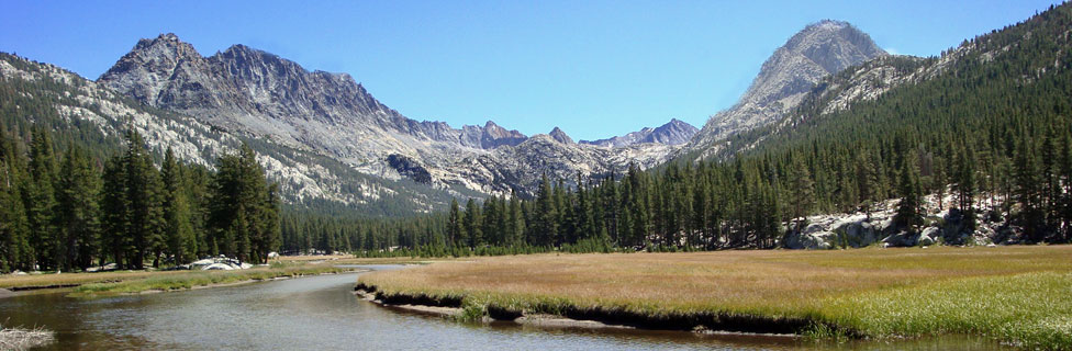
The 54-mile loop from North Lake to South Lake passes through some of the most rugged terrain and spectacular scenery in Kings Canyon National Park. Beginning at North Lake in the Eastern Sierra near Bishop, the trail crosses Piute Pass and descends to meet the John Muir Trail before turning south into beautiful Evolution Valley.

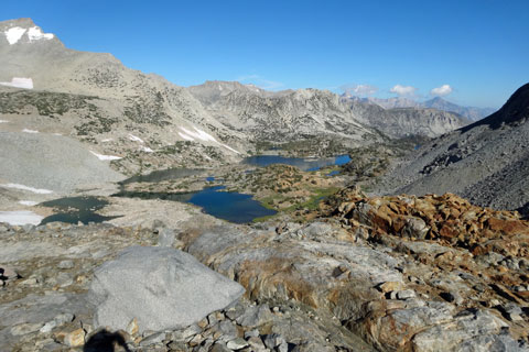
Then hikers climb to almost 12,000 feet over Muir Pass before winding down along the headwaters of the Middle Fork Kings River in LeConte Canyon. Another challenging hike leads up to magnificent Dusy Basin and then over nearly 12,00-foot Bishop Pass. The final miles lead past a series of pretty alpine lakes to a trailhead at South Lake.

Sapphire Lake , Kings Canyon National Park, California

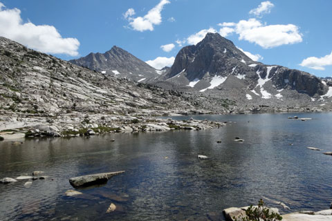
Sapphire Lake and Mount Huxley


North Lake to South Lake
Key Facts


Location: Kings Canyon National Park
Trailhead: North Lake, elevation 9,347'
Piute Pass: 11,460' (2,113' climb)
Muir Pass: 11,955' (3,885' climb from Piute Cr. bridge)
Bishop Pass: 11,975' (3,256' climb from LeConte Ranger Station)
Hiking Distance: 54.4 miles
Best seasons: Mid-summer to early fall
Best Campsites: south of Piute Creek bridge, McClure Meadow, Big Pete Meadow, Little Pete Meadow, LeConte Ranger Station area, Dusy Basin


sign to South Lake, 54. miles

Wildlife

Bears in Kings Canyon have learned that hikers use bear canister and bear boxes to protect their food. Consequently, although you may see bears in the some of the lower elevations along the trail, they are not likely to be a problem. Deer are prevalent in the popular camping areas along LeConte Canyon. They wander in and out of camps unabashedly and will attempt to drag away unattended items (especially backpacks) to lick the salt on them. Rattlesnakes are usually not encountered above 10,000 feet, but hikers should always be wary. Off-trail travelers should be especially vigilant.

Mosquitoes are pesky early summer through mid-August. By late August and through September they are usually not a problem. Meadow areas such as Evolution Valley and Big and Little Pete meadows can often have mosquitoes through mid-summer. Watch for marmots sunning on the rocks on approaches to the passes. Martens are rarely seen but may be spotted among the rocks on the east side of Bishop Pass.

Fishing is good in many of the lakes and in the South Fork of the San Joaquin River as well as the Kings River around LeConte Canyon.


view north from Bishop Pass, John Muir Wilderness, California

Looking North from East side of Bishop Pass


Trekking Poles


BearVault Canister


North Lake to South Lake
Key Facts


Location: Kings Canyon National Park
Trailhead: North Lake, elevation 9,347'
Piute Pass: 11,460' (2,113' climb)
Muir Pass: 11,955' (3,885' climb from Piute Cr. bridge)
Bishop Pass: 11,975' (3,256' climb from LeConte Ranger Station)
Hiking Distance: 54.4 miles
Best seasons: Mid-summer to early fall
Best Campsites: south of Piute Creek bridge, McClure Meadow, Big Pete Meadow, Little Pete Meadow, LeConte Ranger Station area, Dusy Basin


sign to South Lake, 54. miles

North Lake Trailhead

The North Lake trailhead is inside North Lake Campground, 2 miles up a narrow gravel road from the Lake Sabrina Road and 20 miles west of Bishop. No parking is available at the trailhead. Most backpackers planning to leave a car at North Lake drop off packs and someone to guard them at the trailhead while one person in the party drives ½-mile back down the road to the parking lot near the pack station. Restrooms are available at the trailhead, but there is no potable water.

The trailhead is in the Inyo National Forest at an elevation of 9,347'. The road is usually open from May through November.

Similar facilities are found at South Lake and parking there is right at the trailhead. The trip, of course, can also be done from South Lake to North Lake. By road, the two trailheads are about 13 miles apart. Groups with two vehicles have the advantage of leaving one car at each trailhead.

Other pricey options include East Side Sierra Shuttle or the Eastern Sierra Transit Authority, which may be continuing its service connecting South Lake to the foot of the North Lake Road (leaving a 1¾-mile walk up to the parking lot or 2 miles to the trailhead).


Nearby Camping and Lodging

Camping is available at North Lake Campground and is plentiful in Inyo National Forest campgrounds all along the Sabrina Lake and South Lake roads. Camping is not allowed outside of established campgrounds in the area. For more information about campgrounds in the area, see California's Best Camping - Northern Inyo County.

Lodging is available at Parchers' Resort located near South Lake. They have cabins with a range of amenities. Down Sabrina Lake Road (Highway 168) a short distance from the lake is Cardinal Village Resort with housekeeping cabins.