High Sierra Trail - Route Description and Maps, I

Sequoia National Park

Southern Sierra crest from Mount Whitney, Sequoia National Park, California

High Sierra Trail - Route Description and Maps, I

Sequoia National Park


Hiking the High Sierra Trail, Part I

The 71 miles of the High Sierra Trail climb about 15,000 feet and descend about 13,000 feet - a challenging but rewarding adventure. The route traverses the Sierra, beginning at Crescent Meadow on the western slope and concluding at Whitney Portal in the Eastern Sierra. Seasoned backpackers can do the trip in 7 days, while those choosing a less demanding pace might plan on 10 days.

Shop Amazon for: Hiking Poles


Crescent Meadow to Bearpaw Meadow

11 miles

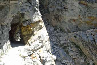
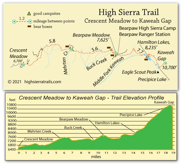
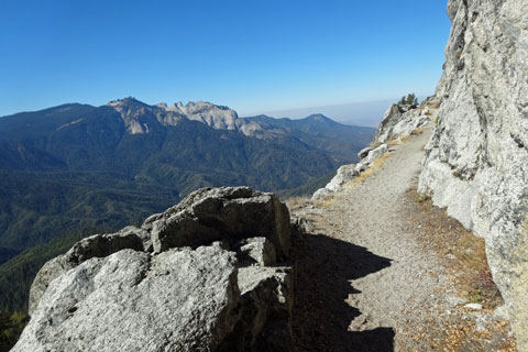
The High Sierra Trail climbs high along the mountainside high above the Middle Fork Kaweah River. In places the trail has been carved out of the rock along precipitous slopes. Hikers are soon rewarded with magnificent views of Castle Rocks across the canyon. After about 6 miles the trail begins to cross a number of side creeks, some of which have good campsites with bear boxes. The final push up to Bearpaw Meadow consists of a series of switchbacks which can be grueling on tired legs.

High Sierra Trail, Sequoia National Park, California

The High Sierra Trail

Camping at Bearpaw Meadow

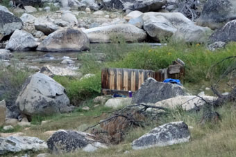
At Bearpaw Meadow is a designated campground for backpackers. No camping in the vicinity outside the campground is permitted. The campground has campsites spread over a large area with good trails connecting them, bear boxes, and piped water available. The water, however, should be treated or boiled before use. Nearby is a High Sierra Camp.
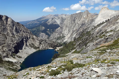
Hamilton Lake, Sequoia National Park, California

Hamilton Lake


Bearpaw Meadow to Big Arroyo Junction

11 miles

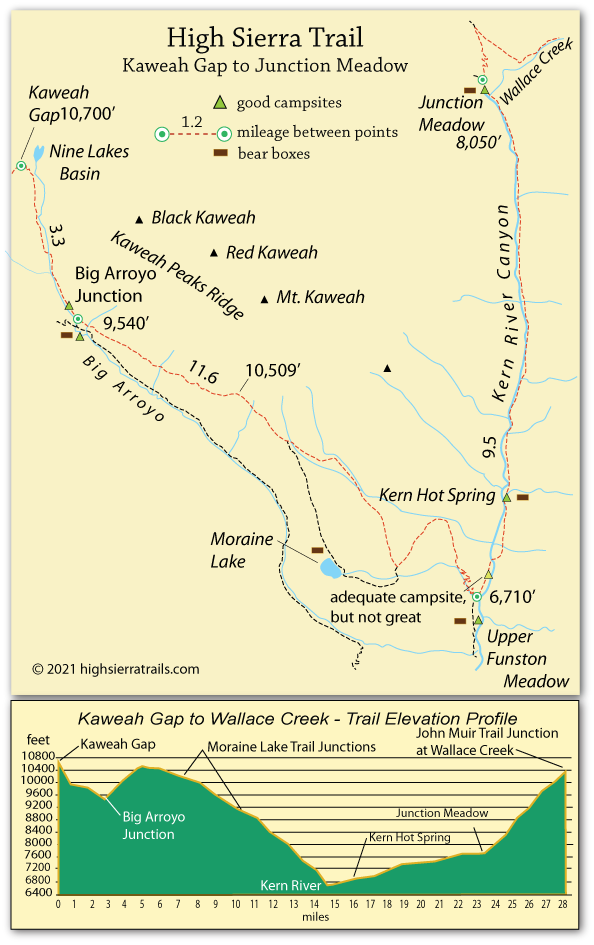
Over the 7.7 miles from Bearpaw Meadow up to 10,700-foot Kaweah Gap, the trail climbs about 3,000 feet. Spectacular scenery along way helps to mitigate the difficulty of the hike. Soon after leaving Bearpaw Meadow, the trail descends to the bridge over the gorge at Lone Pine Creek and then resumes climbing.

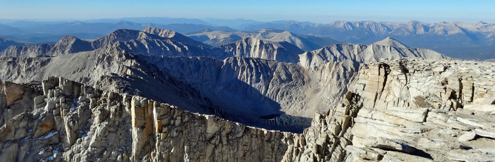
Beautiful Hamilton Lake is a good camping or resting point. Beyond the lake, the trail zig-zags up a steep mountainside, at one point passing through a short tunnel blasted through the granite mountainside. Eventually hikers arrive at photogenic Precipice Lake at 10,300 feet. It is only a short jaunt past the lake to Kaweah Gap. Gaze north into desolate Nine Lake Basin and south down Big Arroyo.
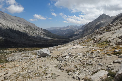
Big Arroyo, Sequoia National Park, California

Big Arroyo

Once across Kaweah Gap, turn south down Big Arroyo, following an easy trail to Big Arroyo Junction. Although the High Sierra Trail continues to traverse the side of the valley, you can take the Big Arroyo trail to the right for a short distance to where you will find good campsites and a bear box, then backtrack in the morning.

Big Arroyo Junction to Junction Meadow

21.1 miles

From Big Arroyo Junction the trail climbs about 1,000 feet, high along the side of Big Arroyo and then begins the long descent to the grand Kern River Canyon. About 4½ miles from Big Arroyo Junction the trail splits. Both trails meet again in a few miles. The right branch leads to Moraine Lake with good camping spots, the left branch is a ½-mile shorter route to the Kern River.

From the point where the Moraine Lake trail rejoins the High Sierra Trail down to the Kern River, the trail descends 2,500 feet. Views of the Kern River Canyon soon appear, offering breathtaking views of the long U-shaped valley. At the river camping is poor. Downstream at Upper Funston Meadow are good camps if you don't mind backtracking in the morning. Upstream, Kern Hot Spring is usually a busy stopping spot.

From the hot spring the trail follows the river for 7½ miles up to Junction Meadow, a flat, spacious area with excellent camping. Trails from several directions converge there and backpackers gather in a congenial setting around campfires, sharing stories of the trail. If possible, plan to make Junction Meadow one of your overnight stopping places.

Bearpaw High Sierra Camp

Bearpaw High Sierra Camp is located at Bearpaw Meadow along the route of the High Sierra Trail, 11.5 miles from Crescent Meadow. The camp has 6 tent cabins with wooden floors and canvas sidings. Each cabin can accommodate 3 people, with 2 twin beds and space for a third person to sleep on the floor. Bedding, towels, and a sleeping pad for 2 occupants are provided.

Breakfast and dinner are served in a dining hall. The camp offers generous portions of home-cooked food, served family-style. Boxed lunches can be purchased separately. The facilities at the camp include a central shower house with flush toilets and hot showers.

The camp is at an elevation of 7,800 feet, resting on a granite saddle overlooking the Great Western Divide. Bearpaw High Sierra Camp is open from June through September. Reservations for upcoming seasons are now bookable 366 days in advance only. They will no longer be opening the full future season’s availability on January 2nd.

Bearpaw High Sierra Camp

Bearpaw High Sierra Camp

Bearpaw High Sierra Camp is located at Bearpaw Meadow along the route of the High Sierra Trail, 11.5 miles from Crescent Meadow. The camp has 6 tent cabins with wooden floors and canvas sidings. Each cabin can accommodate 3 people, with 2 twin beds and space for a third person to sleep on the floor. Bedding, towels, and a sleeping pad for 2 occupants are provided.

Breakfast and dinner are served in a dining hall. The camp offers generous portions of home-cooked food, served family-style. Boxed lunches can be purchased separately. The facilities at the camp include a central shower house with flush toilets and hot showers.

The camp is at an elevation of 7,800 feet, resting on a granite saddle overlooking the Great Western Divide. Bearpaw High Sierra Camp is open from June through September. Reservations for upcoming seasons are now bookable 366 days in advance only. They will no longer be opening the full future season’s availability on January 2nd.

Bearpaw High Sierra Camp


High Sierra Trail Tunnel

Above Hamilton Lake at a chute known as Hamilton Gorge, in 1932 park engineers constructed a steel suspension bridge across the gap; however, in the winter of 1937 an avalanche swept the bridge from its moorings and down the mountainside. The following summer the Civilian Conservation Corps blasted a tunnel through the rock and re-routed the rest of the trail along a ledge.

Tunnel on High Sierra Trail, Sequoia National Park, California

Big Arroyo Junction Guard Station

The old Big Arroyo Guard Station is situated downstream from the trail junction, along the trail leading down into Big Arroyo. The log structure is no longer in use and has been designated as a historical landmark.

Kern Hot Spring

The Kern Hot Spring is 2 miles upstream (north) of the point where the High Sierra Trail reaches the Kern River after descending from Big Arroyo. The hot spring is at the edge of the river. A short wooden fence shields it from passing hikers on the trail.

Kern River Hot Spring on High Sierra Trail, Sequoia National Park, California

Many backpackers hiking along the Kern River Canyon plan to spend a night at the hot spring. A nice campsite is located next to a side-stream, just upriver from the hot spring; but be prepared to find it occupied.

Bears at Junction Meadow

Resident bears at Junction Meadow will snag food that isn't stored properly. Otherwise, they keep to themselves.

Bear at Junction Meadow, Sequoia National Park, California
High Sierra Trail, Sequoia National Park, California

    TOP


High Sierra Trail, Sequoia National Park, California

    TOP