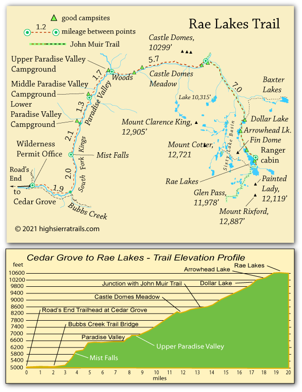
Rae Lakes Trail and Map

Kings Canyon National Park

Rae Lakes, Kings Canyon National Park, California

Rae Lakes Trail and Map

Kings Canyon National Park


Hiking to Rae Lakes

The Rae Lakes Loop is a classic backpacking trip in Kings Canyon National Park. From Cedar Grove, Rae Lakes can be reached by hiking up Bubbs Creek and crossing Glen Pass or, as we describe here, hiking up through Paradise Valley and then Woods Creek to the lakes. Many backpackers then continue from Rae Lakes to complete the loop. Either direction makes a wonderful week-long trip.

Road's End to Upper Paradise Valley,

10 miles

The well-used trail to Paradise Valley begins with a sandy stroll across Zumwalt Meadow (the actual meadow is across the river), but just beyond the turnoff to the Bubbs Creek trail, the climb begins. Pass Mist Falls and then tackle 2 miles of steep switch-backs before entering Paradise Valley. An easy walk through most of the valley is followed by a short climb to the upper camping area.

Shop Amazon for: Hiking Poles


Paradise Valley Camping

Camping is limited to three campgrounds - lower, middle, and upper. There is a 2-day limit in the valley. Each camping area has designated sites, pit toilets, and bear boxes.

old bridge over south fork kings river, Kings Canyon National Park, California

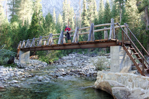
Old Bridge over South Fork Kings River
(Photo taken in September)
Old Bridge Destroyed in Winter 2016-17


Upper Paradise to the John Muir Trail,

5.7 miles

If a new bridge has been erectd, trot across the Kings River and head on up the trail. If there still is no bridge, you will have to ford the river - but only if water levels are safe. In spring and early summer it can be very dangerous. Check on conditions with rangers at Road's End before you set out. If too dangerous, plan your trip to go up Budd's Creek instead of to Paradise Valley.

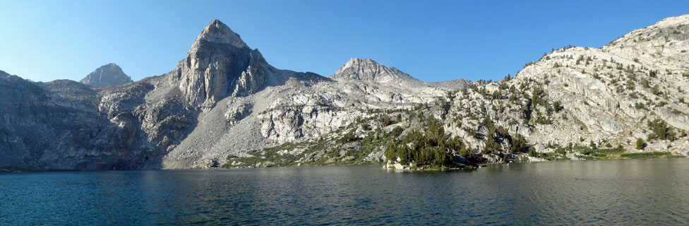
If water levels are safe, cross and start up Woods Creek. Steady climbing through forest soon gives way to an area that burned in 2012. Watch for the grand Castle Domes on your left. Descend to Castle Domes Meadow and then climb again to the junction with the John Muir Trail. Cross the suspension bridge to find good campsites and bear boxes.
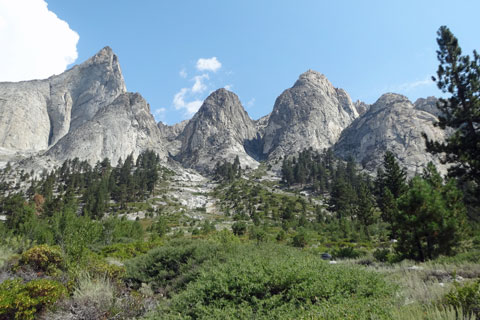
Castle Domes, Kings Canyon National Park, California

Castle Domes


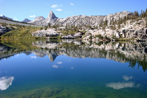
JMT Junction to Middle Rae Lake,

7 miles

Climb steadily up the South Fork of Woods Creek, eventually passing Dollar Lake, Arrowhead Lake, and finally Lower Rae Lake. Middle Rae Lake is just ahead with good campsites.


Dollar Lake and Fin Dome, Kings Canyon National Park, California

Dollar Lake and Fin Dome

Hiking the Rae Lakes Loop

The Ray Lakes Loop is a 41.4-mile circuit beginning and ending at Road's End in Cedar Grove. Here we describe a portion of the trail going clockwise on the loop, through Paradise Valley and up Woods Creek to Rae Lakes. The alternate choice is to turn at the Bubbs Creek Bridge, about 2 miles from Road's End, and following Bubbs Creek up to Vidette Meadow and then over Glen Pass to Rae Lakes.

Those who have come up the Woods Creek route may choose to complete the loop by crossing 12,000-foot Glen Pass and descending Bubbs Creek, 18 miles to Road's End. Glen Pass is a rugged trail, climbing 1,900 feet from Rae Lakes in a little over 2 miles. Then on the south side the trail descends 3,100 feet in 4 miles to Lower Vidette Meadow. Charlotte Lake offers a nice camping spot mid-way down that descent.

From Viddette Meadow the trail follows Bubbs Creek, with good camping along the way. Although choosing Glen Pass and Bubbs Creek is a couple of miles shorter alternative to returning down Woods Creek, the Glen Pass route is more strenuous. Either way is an adventure.

If the South Fork Kings River Bridge (see below) has not yet been replaced and the river is dangerously high, Bubbs Creek is always the better choice, both coming and going, to Rae Lakes.

South Fork Kings River Bridge Alert

Notice: The old bridge crossing the South Fork of the Kings River at the upper end of Paradise Valley was washed out during the winter of 2016-2017. A new bridge is scheduled to be constructed beginning in 2021.

Fording the Kings River, especially early in the season, can be extremely hazardous. The Park Service cautions, "While we can not forecast exact conditions, trips attempting to cross this area may not be possible until sometime in July." Following winters with heavy snowfall, expect dangerous conditions even beyond mid-summer. Check with the Park Service to find out if the new bridge has been completed and, if not, whether it is safe to ford the river: Ray Lakes Loop

Kearsarge Pass

Another trail leading to Rae Lakes comes in from the Eastern Sierra over Kearsarge Pass and then Glen Pass, 11 miles and 5,550 feet up uphill - probably best split into 2 days.

Hiking the Rae Lakes Loop

The Ray Lakes Loop is a 41.4-mile circuit beginning and ending at Road's End in Cedar Grove. Here we describe a portion of the trail going clockwise on the loop, through Paradise Valley and up Woods Creek to Rae Lakes. The alternate choice is to turn at the Bubbs Creek Bridge, about 2 miles from Road's End, and following Bubbs Creek up to Vidette Meadow and then over Glen Pass to Rae Lakes.

Those who have come up the Woods Creek route may choose to complete the loop by crossing 12,000-foot Glen Pass and descending Bubbs Creek, 18 miles to Road's End. Glen Pass is a rugged trail, climbing 1,900 feet from Rae Lakes in a little over 2 miles. Then on the south side the trail descends 3,100 feet in 4 miles to Lower Vidette Meadow. Charlotte Lake offers a nice camping spot mid-way down that descent.

From Vidette Meadow the trail follows Bubbs Creek, with good camping along the way. Although choosing Glen Pass and Bubbs Creek is a couple of miles shorter alternative to returning down Woods Creek, the Glen Pass route is more strenuous. Either way is an adventure.

If the South Fork Kings River Bridge (see below) has not yet been replaced and the river is dangerously high, Bubbs Creek is always the better choice, both coming and going, to Rae Lakes.

South Fork Kings River Bridge Alert

Notice: The old bridge crossing the South Fork of the Kings River at the upper end of Paradise Valley was washed out during the winter of 2016-2017. A new bridge has not yet been constructed (1/2024)

Fording the Kings River, especially early in the season, can be extremely hazardous. The Park Service cautions, "While we can not forecast exact conditions, trips attempting to cross this area may not be possible until sometime in July." Following winters with heavy snowfall, expect dangerous conditions even beyond mid-summer. Check with the Park Service to find out if the new bridge has been completed and, if not, whether it is safe to ford the river: Ray Lakes Loop

Kearsarge Pass

Another trail leading to Rae Lakes comes in from the Eastern Sierra over Kearsarge Pass and then Glen Pass, 11 miles and 5,550 feet of uphill - probably best split into 2 days.


Rae Lakes trail map, Kings Canyon national park, CA

    TOP